
The 2025 Atlantic hurricane season is forecasted to have above-normal activity, which means the time to prepare is now.
|
May 23, 2025 INSIDE THIS ARTICLE, YOU'LL FIND: |
The 2025 Atlantic hurricane season officially runs from June 1 through November 30, and early indicators suggest it could be another active and unpredictable year. With ocean temperatures rising and global weather patterns shifting, storm activity is likely to remain high—and so is the uncertainty around where the worst impacts will be felt.
That uncertainty is what makes this season particularly concerning. While states like Florida, Texas, and the Carolinas are perennially at risk, recent storms have proven that hurricanes can cause significant damage far beyond the coast.
It’s not enough to mark the start of hurricane season on the calendar. Understanding which regions, states, and cities are most often impacted can help guide your planning—but it’s also important to remember that each storm follows its own unpredictable path. Whether you're a homeowner, business leader, or traveler, staying informed about evolving trends—and preparing accordingly—is the most reliable way to reduce risk.
When you're ready to take the next step, download our latest Hurricane Preparedness Guide for detailed planning checklists and actionable steps to protect your people, property, and operations.
The 2025 Hurricane Outlook: What the Forecasts Say
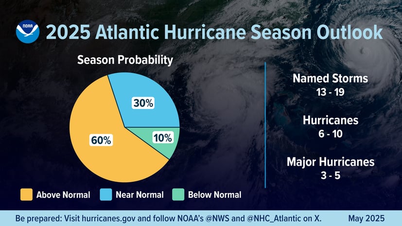
The National Oceanic and Atmospheric Administration (NOAA) issued its official forecast for the 2025 Atlantic hurricane season on May 22.
According to the forecast, there is a 60% chance of an above-normal season, driven by record-warm ocean waters and favorable atmospheric conditions. The forecast also notes just a 10% chance of the season being below normal.
Key Predictions
NOAA’s forecast includes predictions of the number of named storms that will land in the United States. See below for their predictions:
- 13 to 19 named storms (winds ≥ 39 mph)
- 6 to 10 hurricanes (winds ≥ 74 mph)
- 3 to 5 major hurricanes (Category 3 or higher; winds ≥ 111 mph)
- NOAA gives these predictions a 70% confidence level.
Why This Year Could Be Especially Active
Several contributing factors are setting the stage for a busy season:
- Unusually warm Atlantic Ocean temperatures, which fuel hurricane formation and intensity.
- ENSO-neutral conditions, meaning neither El Niño nor La Niña is dominating, which reduces wind shear and favors storm development.
- A potentially northward-shifted West African Monsoon, which can generate long-traveling tropical waves — often the seeds of powerful Atlantic hurricanes.
- A continuation of the “high-activity era” in the Atlantic Basin, characterized by high oceanic heat content and weaker trade winds.
New Forecasting and Safety Tools in 2025
NOAA is rolling out new capabilities to improve early warning and public communication:
- Hurricane Analysis and Forecast System (HAFS) upgrade to enhance storm tracking and intensity forecasts by 5%.
- Tropical cyclone advisory products will now be issued up to 72 hours before storm impacts, such as storm surge or damaging winds.
- An extended 3-week Global Tropical Hazards Outlook for earlier risk awareness.
- Improved graphics and Spanish-language alerts, including inland warning zones and rip current maps.
The Takeaway
NOAA’s experts stress that this forecast is not a landfall prediction—storm tracks depend on short-term weather patterns. But the ingredients for an active season are all in place.
As Cynthia Lee Sheng, the Jefferson Parish President who attended the official NOAA announcement noted, “A community that is more informed and prepared will have a greater opportunity to rebound quickly from weather and climate-related events.”
This is a call to action: make your hurricane plan now—before the storms arrive.
U.S. States Most at Risk in 2025
As noted above, NOAA and other organizations do not make landfall predictions at this stage. While no forecast can precisely pinpoint where a hurricane will make landfall months in advance, historical patterns and geographic exposure help identify which states are statistically most vulnerable. The data tells a clear story: certain regions consistently face more frequent and intense storms.
Even if forecasts don't predict specific landfalls, past is prologue. The states listed here aren't just "coastal"—they're historically storm-tested. And with climate change contributing to slower-moving, wetter, and more intense hurricanes, these regions are likely to remain high on the risk map in 2025.
As you plan for the 2025 hurricane season in the U.S., consider the below, which is a summary of NOAA’s Hurricane Database, featuring hurricane landfall information from 1851-2023.
Florida
Florida is the most hurricane-prone state in the U.S. With coastlines on both the Atlantic Ocean and Gulf of Mexico, Florida has experienced more hurricane impacts than any other state — 129 recorded storms since 1851.
Major cities like Miami, Tampa, Fort Myers, and the Florida Keys are often in the path of high-intensity hurricanes, and many sit at or near sea level, compounding storm surge and flood risks.
Texas
Texas is Gulf-facing and historically active. The Lone Star State has faced 66 hurricanes over the past 170+ years, particularly along its central and southern coastlines.
Houston, Corpus Christi, and Galveston are highly susceptible due to rapid coastal development, oil infrastructure, and flat terrain that can amplify flooding.
Louisiana
Though hurricanes don’t land here as frequently as the top two states, Louisiana is ground zero for some of the nation’s worst storms. With 64 hurricane hits, Louisiana ranks just behind Texas.
New Orleans and Lake Charles have faced multiple catastrophic events, including Hurricanes Katrina (2005), Laura (2020), and Ida (2021). Low elevation, extensive levee systems, and proximity to the Gulf make the state extremely vulnerable.
North Carolina and South Carolina
There are rising risks along the growing coastline of the Carolinas. North Carolina (59 storms) and South Carolina (33 storms) are no strangers to hurricane impacts, especially cities like Wilmington, Charleston, and the Outer Banks.
Rapid population growth and real estate development in low-lying areas increase the risk profile—even for Category 1 or 2 storms.
Alabama, Mississippi, and Georgia
The states of Alabama, Mississippi, and Georgia are often overlooked, but increasingly exposed. Though less frequently mentioned, these states have a combined total of over 80 hurricane impacts.
Cities like Mobile (AL), Biloxi and Gulfport (MS), and Savannah (GA) are no strangers to storm surge and wind damage. And inland cities like Atlanta and Columbus have experienced major disruptions from inland flooding and power outages.
Caribbean and International Hurricane Risk in 2025
While much of the attention each year focuses on U.S. coastal states, many international locations across the Atlantic basin—particularly in the Caribbean, Central America, and parts of North America—face a high statistical risk of hurricane landfalls. These countries often bear the brunt of early or mid-season storms that form in the deep tropics or gain strength while passing over warm Caribbean waters.
The below is a summary of NOAA’s international Atlantic hurricane landfalls via their Hurricane Database (from 1946-1970 and 1983-2023):
- Mexico: 47
- Cuba: 41
- Bahamas: 38
- Canada: 11
- Belize: 10
- Nicaragua: 9
- Haiti: 8
- Puerto Rico: 6
- Bermuda: 6
- Dominican Republic: 5
- Jamaica: 4
- Honduras: 4
- Hispaniola: 3
- Guatemala: 3
- Panama: 2
- Grenada: 2
- Antigua: 1
- Barbados: 1
- St. Kitts: 1
- Martinique: 1
- St. Lucia: 1
Mexico, Cuba, and the Bahamas alone account for over 120 hurricane landfalls—more than any three U.S. states combined over the same period.
High-Risk Destinations in 2025
- Yucatán Peninsula (Mexico): Cancun, Cozumel, Playa del Carmen
- Cuban Coastlines: Prone to both Gulf and Atlantic hurricanes
- Bahamas: Frequently struck by intense, fast-moving storms
- Hispaniola (Dominican Republic & Haiti): High terrain worsens flood risks
- Belize and Honduras: Coastal areas especially vulnerable to storm surge
Whether you're traveling, investing, or living in these regions, it's critical to stay informed and ready—especially as warming ocean temperatures increase the likelihood of rapid storm intensification.
Hurricane Risk Is Everywhere
Hurricanes are no longer confined to the coastline. Inland cities like Orlando (FL), Columbia (SC), Atlanta (GA), and Richmond (VA) may not top the list of hurricane-prone destinations, but they’re increasingly vulnerable.
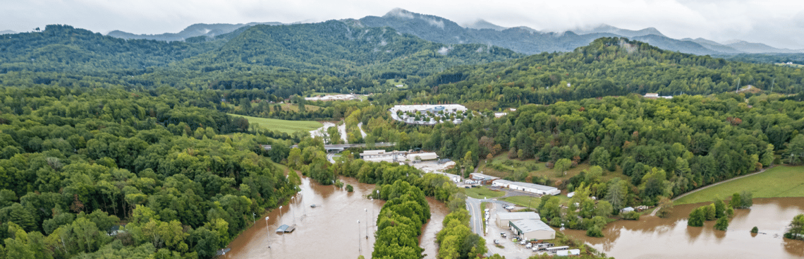
In 2024, Hurricane Helene made this clear. After coming ashore on the Gulf Coast, the storm pushed hundreds of miles inland and dropped over 30 inches of rain on Asheville, North Carolina, unleashing devastating floods in a region once considered safely out of harm’s way.
In addition, hurricane risk isn’t just unpredictable regarding location, but in terms of how quickly a storm can form. As Ken Graham, Director of the National Weather Service, warned: “The strongest hurricanes are the ones that developed the fastest... Every Category 5 storm that’s ever hit this country was a tropical storm or less three days prior.” His point is clear: hurricane risk is no longer just about where you are on the map—it’s about how fast things can change. And in 2025, any community in the storm’s path needs to be ready before the forecast catches up.
Why Hurricane Risk Changes Every Year
Hurricane paths are influenced by a mix of atmospheric and oceanic conditions—including wind shear, sea surface temperatures, pressure systems, and global climate drivers like El Niño and La Niña. A slight change in any of these variables can shift a storm’s direction, speed, or intensity.
That’s why cities like New Orleans, Houston, or Tampa may experience multiple hurricane landfalls in a short period, while other vulnerable locations see long gaps between direct hits. Prior seasons offer no guarantees about what’s ahead.
Some seasons see multiple hurricanes affecting the same area, a phenomenon referred to as “clustering.” In 2020, five named storms struck Louisiana. In 2004, four hurricanes crossed Florida in just six weeks. These events are driven by short-term seasonal conditions, not long-term cycles, and they can happen anywhere.
While most hurricane activity occurs between August and October, storms can still form and intensify in the early and late edges of the season. Late-season hurricanes can form close to land and strengthen quickly, reducing the amount of warning time. This was the case with Hurricane Michael (2018), which reached Category 5 status just before landfall.
As storms become stronger and slower-moving, their effects reach farther—meaning even historically low-risk areas need to prepare. This underscores the main takeaway: Hurricane risk isn’t fixed. Each season is shaped by new variables, and the only consistent defense is preparedness.
How to Prepare Now
The key to staying safe during hurricane season is preparation before a storm is on the radar. The more steps you take now—while skies are clear and resources are abundant—the more resilient you, your family, and your organization will be when conditions change.
Note that NOAA does offer its official National Hurricane Center tool for monitoring and understanding tropical cyclones in the Atlantic and Pacific basins. It delivers real-time updates on storm activity, including forecasts, track maps, wind speed probabilities, and marine conditions. Users can view current storm outlooks, explore satellite and radar imagery, and access detailed forecast discussions from NOAA experts.
In addition, Global Guardian’s 2025 Hurricane Preparedness Guide offers detailed checklists, region-specific recommendations, and critical contact templates to help you prepare effectively and confidently. Download the guide today to get a head start before the season begins.
As the 2025 Atlantic hurricane season begins, the only certainty is uncertainty. Whether you're in a high-risk coastal zone or a seemingly safe inland city, now is the time to review your plans, strengthen your resources, and stay connected to trusted forecast tools like the National Hurricane Center. Because when a storm is on the way, the steps you take today can make all the difference.
Standing by to Support
The Global Guardian team is standing by to support your security requirements. To learn more about our security services, complete the form below or call us at + 1 (703) 566-9463


